Have questions?
what is simTainment™?
request more information
Product Brochure
download now
-
- discover our unique selection of simTainment™ products for Microsoft Flight Simulator and X-Plane
- GTN 750/650 Touch™
- GNS 530W/430W V2™
- General Aviation T-Stack
- Analogue Navigation Gauges
- Wx500 XP™ Weather Radar
- See all
-
- combining traditional training and simulation expertise with novel approaches from the gaming industry to provide RealTime Training™
- RealTime Training™
- Microsoft ESP™
- See all
-
- we serve consumers, developers and enterprises helping deliver lowest overall cost and greatest competitive advantage
- Services we offer
- Industries we serve
- White papers
- About us
- top features
- closer look
- in depth
From the first look, you will know that your Flightline Apollo radio stack is different than what you have been used to. You'll be amazed at the accuracy of the modeling of the units within Flight Simulator. And since it is a Flight Simulator gauge, you'll be also surprised at how easy it is to add the Radio Stack and the GPS to your favorite aircraft, and how perfectly the avionics integrates into your aircraft panels.
Built with discriminating pilots in mind, the Flightline Apollo is unequaled in providing the features, level of performance and reliability that flight simulation users require.
Authentic Avionics Simulation

Flightline Apollo represents the next step in simulated Avionics solutions for Flight Simulator 2002. The new offering provide an ultra-realistic simulation of the UPS Aviation Technologies Apollo GX and Slim Line series of avionics products.
The Reality XP avionics simulator delivers enhanced realism, providing a solid training aid for users of the UPS Aviation Technologies avionics.
Enhanced Realism
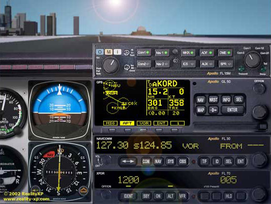
Since its introduction in March 2002, Flightline Apollo has set new standards for Flight Simulator. The Apollo is the most amazing GPS and Radio Stack for Flight Simulator. From the accuracy of the GPS simulation, to the extended list of features and the authenticity of its operating mode, no wonder it is also the only Flight Simulator add-on sealed with the acclaimed UPS Aviation Technologies GPS brand: Apollo
Navigation
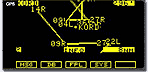
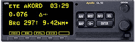 estimated time enroute to KORD is 3.29min. Distance to
KORD is 9.42nm and we are 0.076nm off-track. The CDI
tells the Desired Track is to our right
Flightline Apollo GPS is a real Navigation Computer with advanced features. You know precisely where you are with map and trip data as you navigate from one place to the other. The Navigation pages are the pilot’s best source for all the needed navigation data and all in one single and convenient place.
There is no safe flight without an accurate depiction of the terrain you are flying over. With its unique Minimum Safe Altitude and Minimum Enroute Safe Altitude, the GPS not only tells you where you are, but also where you are going. Practicing VFR? with the sunrise and sunset page, you'll know if you can reach your destination waypoint before night falls.
Database
Lost with your charts? the GPS is the handy companion for providing accurate and detailed information from its large database. It is a real navaid encyclopedia at your fingertips! From any waypoint, press the INFO key and turn the pages!
Should you need to quickly find an alternate, the Nearest Search function will provide the closest Airports and the GPS will guide you to your choice safely. An Extensive database with up to 200,000 user waypoints, the Flightline Apollo has more to offer than any other navigation solution.
Flight Planning
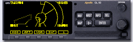 comprehensive moving map with Airport,
Navaid and Airspace display.
Compatible with the Flight Simulator flight plan files, setting up your GPS is a snap: just browse the available files and activate! With its advanced GPSS (GPS Steering) featuring turn anticipation and support for Cross Wind Correction, flying from A to B has never been easier.
Moving Map
The Apollo GPS is the perfect companion for your trips, whether it is a quick trip around your local airport or an entire cross-country adventure. The moving map is the most used and useful feature for situational awareness. With its scale ranging from 0.1 to 250nm, smart keys to declutter the display and the active course line from your flight plan, you'll never say again: where am I?
Flightline Apollo also features a convenient airspace display. Use the Apollo to find the correct ATC frequencies communications and plan your route to your safely to your next destination.
Workoad Reducing Functions
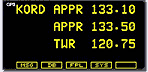
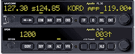 contact KORD approach, in COM mode:
retrieve and tune the frequency with 2 keys!
Flight Line Avionics Radio Stack is linked to the GPS to retrieve Airport, ILS and VOR frequencies with a few key presses. You instantly tune your radio to the most needed frequencies at the most needed time in a snap!
During a flight plan following, the next TO waypoint frequencies are automatically updated too!
Advanced Features
Navigation has never been easier with the NAV/COM radio. Its unique graphic CDI provides an automatic scale to accommodate both VOR and LOC precision. Even more, simply press the OBS key twice to auto center the CDI!
For the most demanding pilot, the NAV/COM radio provides an extensive memory of 250 user frequencies, each with its own name and type!
Last but not least, the Audio Panel is a marvelous piece of technology. With its integrated and customizable Aural Warning System, it reminds you of any failure in the Aircraft and Engine systems!
General Features
- left and right mouse buttons support for the knobs
- database tool to build and maintain the GPS database
- support for up to 200,000 user waypoints with up to 48 characters description
- nearly 15000 airspaces worldwide (class B, C, D, MOA, Alert, Caution, Danger, Restricted, Prohibited, Warning, National park)
- Apollo Config Software for quick and easy panel retrofit
Audio Panel FL15M
- volume control knob for OMI marker sound and key beeps
- Transmit Indicator linked to Flight Simulator ATC window
- 10 channels audio
- mutable OMI sound
- back lighted panel, buttons and knobs
- full Apollo SL15M audio panel logic for TX/RX selection
- Aural Warning System
GPS GL50
- 160x80 electro luminescent display with bicubic filtering for accurate screen resizing
- screen auto-dimming according to local time or user preference
- countdown timer
- comprehensive waypoint database with advanced search modes on any field
- find airports, VOR, NDB and waypoints in a 600nm radius
- user selectable runway limits and surface type to filter the search
- message alerting system with next track and heading (corrected for cross wind) in flight plan following
Airport Information Pages
- Identifier, City, Facility name, State, Country
- bearing and distance From / To present position
- radio communication frequencies
- airport type and elevation
- runway map, length and surface types
- lat / lon coordinates
- sunrise / sunset times
VOR and NDB Information Pages
- Identifier, Facility name, State, Country
- radial and distance from the VOR
- bearing and distance from present position
- operating frequency
- lat / lon coordinates
- sunrise / sunset times
Waypoint Information Pages
- Identifier, State, Country
- bearing and distance from present position
- lat / lon coordinates
- sunrise / sunset times
Moving Map Mode
- condensed or full screen
- Navigation information and scale selection
- Destination Waypoint, Distance and Ground Speed
- Bearing and Track
- Cross Track Distance and Direction
- Auto scale and fixed scale modes
- 5 nm ATC ring for airports with control tower
- current active leg and active flight plan legs
- user selectable map declutter feature
- filter function with user selectable runway limits and surface type for airports
- airspace display with declutter per-airspace type
- flight path history mode with complete user parameters
- Map orientation (track, desired track or magnetic north)
- Map center reference (plane or destination)
Navigation mode with 8 pages of information
- current TO waypoint, ETE, Cross Track with auto scale and CDI, bearing and distance
- desired track (DTK) and distance
- track angle and track angle error
- ground speed and flight time
- bearing and track angle
- time UTC
- Minimum Safe Altitude and Minimum Enroute Safe Altitude with ETA
- GPS position and simulated PDOP
- Auto-Nav mode to cycle the pages automatically
Flight Simulator flight plans
- load, browse and activate flight plans
- automatic flight plan following
- user selectable active leg
- auto insert of the Direct TO waypoint
- GPSS (GPS Steering / autopilot coupling) with turn anticipation
- ETA, leg ETE and ETE information
System settings
- Auto-nav time delay
- automatic or manual magnetic variation
- flight timer trigger settings
- CDI scaling
- display test mode
- display brightness setting
- owner name
Nav/Comm. FL30
- 32 5x7 dot matrix alphanumeric display
- transmit indicator with the Flight Simulator ATC Window
- on/off mode
- stuck mic feature
- audio ident and sound multiplexing with com audio
- DST display (distance, speed, time)
- CDI with automatic scale and additional information (to/fr flag, radial)
- OBS setting
- auto-center CDI mode
COM mode with standby and active frequencies
- communication monitor mode to listen to both frequencies at the same time
- user memory of up to 250 frequencies with their name and type (GND,TWR...)
- last 10 used frequencies automatic memory
- GPS automatic frequency downlink
- emergency channel direct access
NAV mode with standby and active frequencies
- morse code decoding
- user memory of up to 250 frequencies with their runway number for LOC
- last 10 used frequencies automatic memory
- GPS automatic frequency downlink
Transponder FL70
- off/on mode
- manual ident, standby, A/C modes
- VFR fast dial code
- altitude hold mode with user set altitude warning buffer