Have questions?
what is simTainment™?
request more information
Product Brochure
download now
-
- discover our unique selection of simTainment™ products for Microsoft Flight Simulator and X-Plane
- GTN 750/650 Touch™
- GNS 530W/430W V2™
- General Aviation T-Stack
- Analogue Navigation Gauges
- Wx500 XP™ Weather Radar
- See all
-
- combining traditional training and simulation expertise with novel approaches from the gaming industry to provide RealTime Training™
- RealTime Training™
- Microsoft ESP™
- See all
-
- we serve consumers, developers and enterprises helping deliver lowest overall cost and greatest competitive advantage
- Services we offer
- Industries we serve
- White papers
- About us
- top features
- see it in action
- in depth
Best-in-Class situational awareness
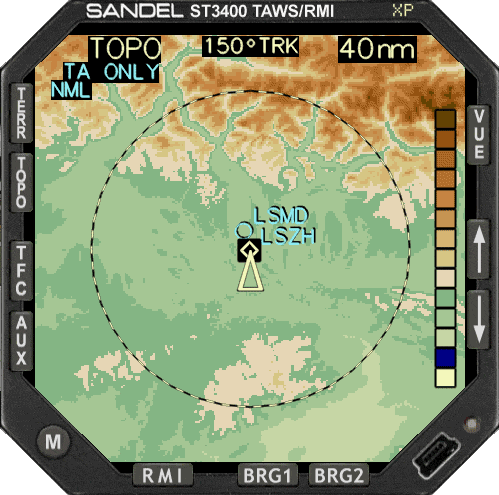
The TOPO selection button is used to display a topographical view of the terrain in sectional chart colors. A color scale guide is provided on the right side of the display as a helpful on-screen guide to relative color coding. The TERRain button toggles the display between RELative altitude mode, which color-codes terrain above and below the current aircraft altitude, and PREDictive altitude mode, which color-codes based on the aircraft’s future altitude.
Topographic (TOPO) and Predictive Altitude (PRED) features provide the pilot with fast access to new types of useful information maximizing the pilot’s understanding of the relationship between the aircraft and the ground in different flight situations. An image of the surrounding terrain is represented in various colors. Terrain forward, behind and to the side of the aircraft is displayed.
Best-in-class TAWS
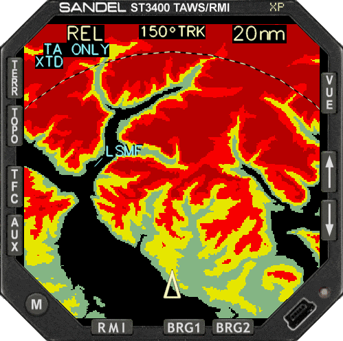
In addition to the six GPWS alerts, the ST3400 provides predictive “look ahead” warnings by comparing its internal terrain database to position information provided by the GPS or FMS navigator. The internal terrain database provides the basis to look ahead of the aircraft and detect terrain or obstacle conflicts. This is accomplished based on aircraft position, phase of flight, flight path angle, track, and speed relative to the terrain database image forward of the aircraft.
Through sophisticated look-ahead algorithms, alerts are generated if terrain or an obstacle conflict with the flight path angle of the aircraft. This potential conflict area projects forward and to the side of the aircraft.
TAWS and beyond: Predictive mode
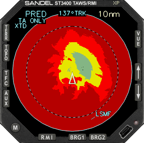
The Predictive Altitude Display Area is a circular conic up to 13 nm in radius within which the future altitude of the aircraft (based on current conditions) is compared to the terrain heights and then color coded. PRED is useful when used in climbs and descents by visually presenting the terrain situation farther into the future than FLTA alert itself. This provides the pilot a means to avoid alerts before they occur. In a climb, PRED will clearly show the terrain the aircraft is out-climbing in its current configuration. This feature can give useful information during an engine-failure scenario in a terrain-rich environment.
A TAWS, an RMI and a TCAS display
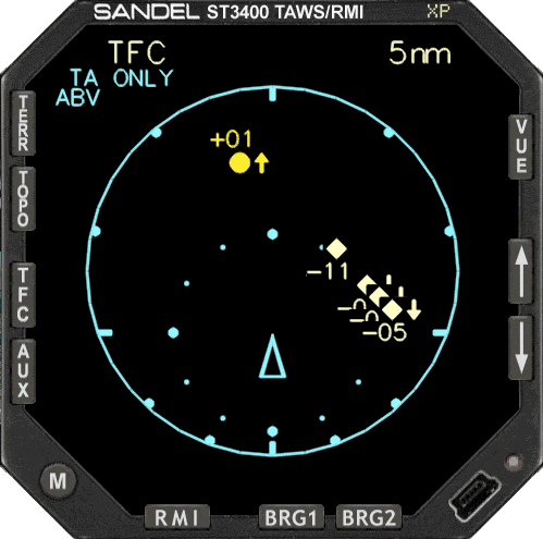
The TFC selection button is used to display traffic data from nearby transponder equipped aircraft. The RMI display shows a traditional 360 degree compass rose. A symbol in the center represents the aircraft’s current position. The compass card display rotates in relation to changes in the heading. The RMI display can show two independent bearing pointers - primary and secondary. Each pointer is fed from an individually selected navigation receiver source. The primary pointer is displayed as a single needle. The secondary pointer is displayed as a double needle. The head of each bearing pointer indicates the bearing to the navigation source and the tail of each pointer indicates the bearing from the navigation source.
Works with any Flight Simulator Terrain Mesh
The great advantage of the ST3400 over other products, is that no database of terrain data needs to be installed. The instrument draws directly from the flight simulator installed mesh files. This gives you an authentic picture of the topographical data and it does not matter whether you fliy with the standard scenery, addon meshes or whatever resolution is underway: It displays what is installed.
With its impressive performance and features, the ST3400 also raises the bar in display technology. Using an advanced display technology developed for the newest generation of avionics simulation, the ST3400’s bright, high-contrast screen gives you incredible readability at any displayed size.
In short, with its highly accurate terrain hit detection in both horizontal and vertical extension, the ST3400 offers the Best-in-Class simulated TAWS: What you see is what you REALLY get!
ST3400 In action
Complete Sandel ST3400 Simulation
The industry's best-selling integrated TAWS for corporate, regional and air transport markets outperforms cumbersome remote-mount TAWS systems. Enhancing safety and situational awareness, the revolutionary ST3400 TAWS/RMI features terrain maps, topographic maps, navigation waypoint maps and TCAS data.
You will be flying a simulated avionics package capable of providing the same features and benefits as the real avionics. The Sandel ST3400 XP package is a faithful reproduction that pilots and simmers can use it as a training tool to familiarize themselves with the workings of the actual equipment. Each button and knob is fully functional and performs identically to its real-world counterpart.
Sandel ST3400 XP also features:
- TCAS I and Mark V GPWS (Modes 1-6) included.
- TAWS (EGPWS) FLTA and PDA modes.
- Audible and Visual Alerts/Warnings (30 and 60 seconds prior to impact).
- Visual indicators of collision/impact site.
- Highly optimized terrain and TAWS algorithm for none to little performance hit.
- Uses Flight Simulator Terrain Mesh for best-in-class simulated TAWS.
- No extra CD/DVDs to install or large terrain data sets to download from the internet.
- Works with any add-on mesh at any resolution.
- Complete Airport database.
- Integration with any Flight Simulator GPS and flight plan display.
- RMI needles with User-selectable data source.
- Replaces any gauge in any Panel.
- High resolution Photo-realistic gauges bitmaps.
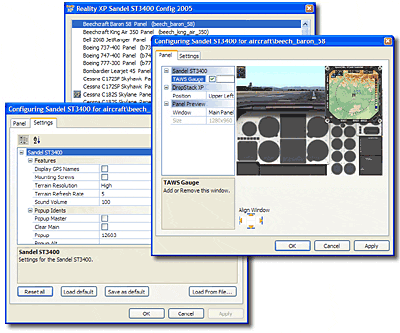
Easy Gauge Configuration
Sandel ST3400 XP Config software designed to configure and manage your Reality Sandel ST3400 XP gauge settings with a user-friendly interface and powerful configuration options. Easily change the type and rendering options for your gauges with your mouse.
In addition, quickly add a popup window to any panel.