Flightsim Products
gauges simulation and addons products for Flight Simulator.
Professional Simulation
professional and training products for Microsoft ESP.
Simulation Services
consulting, integration, training and technologies.
-
- discover our unique selection of simTainment™ products for Microsoft Flight Simulator and X-Plane
- GTN 750/650 Touch™
- GNS 530W/430W V2™
- General Aviation T-Stack
- Analogue Navigation Gauges
- Wx500 XP™ Weather Radar
- See all
-
- combining traditional training and simulation expertise with novel approaches from the gaming industry to provide RealTime Training™
- RealTime Training™
- Microsoft ESP™
- See all
-
- we serve consumers, developers and enterprises helping deliver lowest overall cost and greatest competitive advantage
- Services we offer
- Industries we serve
- White papers
- About us
- at a glance
- top features
What is GNS 430/530 WAAS?
Reality XP brings to market a cost effective software only simulation solution of the popular GPS devices, in offering nearly the same level of functionality the hardware Garmin Simulator version of the GNS 430 WAAS and GNS 530 WAAS offer at a fraction of the purchasing and operating costs.
Already available in several implementations, like our award winning GNS 430 WAAS XP and GNS 530 WAAS XP simTainment products for Flight Simulator 9 and X, Aviation Supplies & Academics ASA OnTop and the latest Elite Software Solution ELITE Premium FAA approved simulators, the Reality XP GNS 430/530 WAAS simulation is now available for Microsoft ESP™
GnsCore XP™
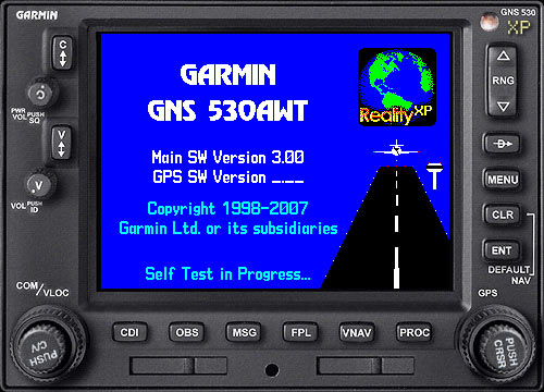
GnsCore XP is our unique technology that integrates with the Garmin GNS WAAS Trainer program. The Garmin Trainer is Garmin's software simulation of the Garmin GNS 430W/530W running on the PC. Nearly all functions and features of the real GNS 430W/530W are simulated with the Garmin Trainer. It comes as a complete installer including the simulation software, a complete Jeppesen® navigation, terrain and obstacle database, and the complete GNS 430W/530W Pilot's guides and documentation.
Reality XP solution extends and bridges the trainer program with the host simulation application. Thanks to running native GNS WAAS Trainer in the background automatically, this allows us to offer extended simulation and control capabilities to the GPS within Flight Simulation programs:
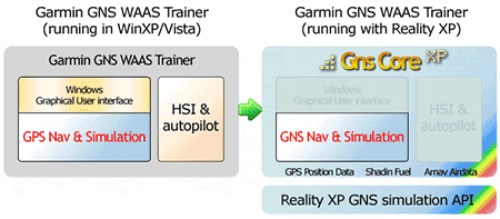
GnsCore XP offers key enhancements to the solution:
- Minimizes overhead by just running what is required.
- Duo/Quad/Multi core CPU optimizations.
- Precise and direct control of many GNS simulation core parameters.
- Several key ARINC/Serial inputs like Shadin Fuel, Arnav Airdata, Ryan TCAD.
- Several key ARINC/Serial outputs like Aviation Data.
- Avionics Electric Bus interface.
- Capability to run more than one Trainer at the same time on the same computer.
Available Products and Solutions
Reality XP GNS 430/530 WAAS simulation for Microsoft ESP™ share the same level of integration and accuracy of our award winning Flight Simulator 9 and X products. In addition, the product comes with a documented Application Programming Interface (API) that permit developing custom software around the GNS simulation like hardware encoders and proprietary navigation gauges.
The Reality XP GNS 430/530 WAAS simulation is available as an extension to Microsoft ESP™ in the form of a Gauge pack. Third party vendors can license our Core Garmin GNS WAAS simulation technology for inclusion in their products.
Contact us to request more information for GNS 430/530 WAAS Professional Simulation
Resources
Fly WAAS Approaches
Like its real world counterpart, the GNS 530W XP comes with built-in WAAS navigation capabilities, and is capable to fly LPV “glideslope” approaches without reference to ground-based navaids of any kind. Featuring an advanced 15-channel receiver capable of five position updates per second, GNS 530W meets the FAA's stringent TSO C146a standards for WAAS "sole means" navigation — providing vertical and lateral approach guidance into thousands of U.S. airports previously inaccessible in IFR conditions.
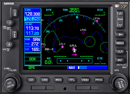
Get High-Resolution Mapping

Effective use of color makes it easy to see your position relative to ground features, chart data, navaids, flight plan routings, approach procedures and more.
Put It on Autopilot
Working in tandem with the Microsoft ESP™ autopilot with a proprietary roll-steering command interface, GNS 530W XP behaves like a high-end flight management system (FMS) and can automatically fly your aircraft through holding patterns, procedure turns and other position-critical IFR flight procedures.
Enhance Situational Awareness
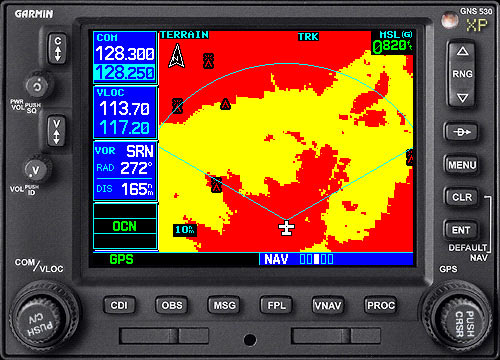
GNS 530W XP seamlessly integrates built-in terrain and navigation databases, providing a clear, concise picture of where you are and where you’re heading, using the Garmin Ltd. Trainer huge Jeppesen® database containing location reference for all airports, VORs, NDBs, Intersections, Flight Service Stations, published approaches, SIDs/STARs, Special Use Airspace and geopolitical boundaries. A detailed basemap clearly shows airports, cities, highways, railroads, rivers, lakes, coastlines and more. Using information from the built-in terrain and U.S. obstacles databases, the 530W XP displays color coding to graphically alert you when proximity conflicts loom ahead.